Connect The Trails, Connect Our Community
Since 1989, Manuels River Natural Heritage Society has been working to protect, conserve and enhance the Manuels River system, through wildlife habitat improvement, operation of an interpretation centre, the delivery of various educational programs, and the development of Manuels River trail system.
The Master Plan is multiple phases of implementation with the expectation that the sequence of implementation may be adjusted over time to reflect funding opportunities, altered priorities or other factors that may come into play. Priorities for development are based upon an assessment of safety concerns, environmental conditions, limits to accessibility, logical construction sequence and priorities identified by the community and stakeholders during the consultation process. Fabrication and installation of wayfinding signs along the trail for each segment will need to occur as well.
The development of Manuels River Trail System is to improve the current walking trails, with an emphasis on maximizing safety, accessibility and the visitor experience. This trail development connects our centre to the ocean, opening up a view like no other. The Connected Trails will increase the possibilities of how we can grow as an organization; enhancing our tourism offerings as an economic driver for our community and supporting our sustainability as a registered Canadian charity and non-profit organization that depends on community support.
Phase 1 Accomplishments
The main goal of Phase 1 of the Master Plan was to upgrade sections of the main trails, Canyon Trail (upstream of the Centre) and Ocean Trail (downstream of the Centre) starting at the Centre and moving out toward significant locations and gateways within the community. Among other issues, flooding issues were addressed and system looping increased.
During Phase 1, a new naming structure was selected for the trail system with upstream trails (south of the Centre) being named Canyon Trail (East and West on either side of the river), and downstream trails (north of the Centre) being named Ocean Trail (East and West on either side of the river).
This phase created 2.7 kilometres of upgraded trails. The following summarizes the work completed in Phase 1:
• Canyon Trail East was upgraded from the Centre to the T’Railway – a secondary gateway. All wooden structures including steps and boardwalks were removed from the trail so that the entire surface is now hard-packed gravel with gentle slopes. Upgrading of this section also created a fully accessible loop from the Centre with the provincial T’Railway making up part of the looped route.
• Ocean Trail West was upgraded from the Centre to Martha’s Place – a secondary gateway. All wooden structures were removed from this section as well. Where steps were required to remain because of steep slopes, walk-around of gravel surfaces with accessible slopes were added to by-pass the steps where possible. Wooden steps were replaced by granite steps where steps had to remain. As well, portions of Ocean Trail were built up to address regular flooding including flooding that made one of the two fossil sites inaccessible.
• The two pedestrian bridges on Ocean Trail West – Kingfisher Bridge and Blue Jay Bridge – were widened to allow for access by maintenance and first responder vehicles.
• The trail system Primary Gateway was redeveloped from gravel surface parking to asphalt with barriers (stone walls) to direct visitors to use the crosswalk on Route 60 instead of crossing the four-lane highway in a dangerous manner which had been a safety issue.
• Primary gateway, secondary gateway and wayfinding signage were added to the upgraded sections of Canyon Trail East and Ocean Trail West.
Phase 2 Accomplishments
The main goal of Phase 2 of the Master Plan was to upgrade sections of the ocean trail and to connect both Ocean Trail East and Ocean Trail West to the coast. The development would remove unnecessary barriers from trails, upgrade trails for use by all, and where possible create new accessible trail sections along the river edge. The other goal was to upgrade the trail from Kingfisher Bridge to Bubble Pond Lookout. Due to availability of funding, his phase was divided into Phase 2A and Phase 2B.
Phase 2A Accomplishments
This phase created 1.9 kilometres of upgraded trails. The following summarizes the work completed in Phase 2A:
- From Blue Jay Bridge to Bubble Pond, a new segment was added to Ocean Trail (East) along the river edge. This development provides accessibility to the Trilobite fossil site, stabilizing the site to protect the fossils from risks of silting.
- Ocean Trail East from Bubble Pond to the end of developed trail (marker #17) below Hazel Place, was upgraded and stabilized the bank along the river to create a trail that is accessible to all. The wooden boardwalk was removed.
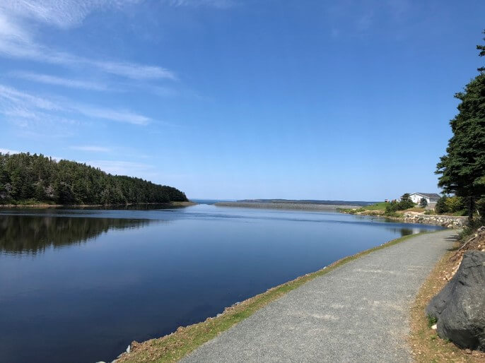
- Beyond marker #17, Ocean Trail East was extended to the coast along the river edge, taking the pedestrian foot traffic off private property and keeping all visitors on the Manuels River trail. This entailed clear cutting, increasing levels of rock formation with boulder along the river edge (soil on the land side and stone on water side) to address flooding of the trail.
- To Connect to the Coast, a path was created to extend the trail to the beach along the bank of grass below the parking lot of Worsley Park. The trail was cut as close to the river edge as possible, the grade and level is consistent along the trail as it connected to the end of Laurel Road. At Worsley Park, the bank was stabilized and an easement into the river was created to support safe access for non-motorized watercrafts.
This phase segment accomplished the first part of our main goal, to Connect the Coast, and marks the completion of 4.5 kilometers of developed trails.
Phases left to complete:
Phase 2B
With the completion of Phase 2B, 1.35 kilometers of trail will be developed through improvements and extensions of the Manuels River Trails System.
Bubble Pond Look-Out: To upgrade and widen the existing trail, removing all wooden boardwalks and replacing them with gravel surfaces incorporating geotextile fabric for drainage. All wooden steps on upgraded section will be replaced by graded gravel surfaces where possible, or with stone steps where slopes are too aggressive for a graded gravel surface.
At Bubble Pond Look-out a fence will be installed to create a safe place for visitors to capture pictures of the picturesque view of the Manuels River Valley and the Atlantic Ocean in Conception Bay.
The Ocean Trail West – Martha’s Place to the Ocean: To upgrade and widen the existing trail and extend it to Conception Bay on the west river bank.
Phase 3
With the completion of Phase 3, 1.4 kilometers of trail will be developed through improvements and extensions of the Manuels River Trails System.
Phase 3A
The Canyon Trail – East: T’Railway to The Canyon East involves the upgrade and widening of the existing trail, removing all wooden boardwalks and replacing them with gravel surfaces incorporating geotextile fabric for drainage. This phase will open the canyon area up for the natural history experience it offers and make it accessible to more people who want to experience the picturesque view.
Phase 3B
T’Railway to The Canyon West- Extend Canyon Trail West from T’Railway to The Canyon along the river edge. This segment is only focused on expansion of the trail, stabilizing the river banks by increasing levels of rock formation to 4 feet with boulder along the river edge (soil on the land side and stone on water side). This new development will connect the trail system in a loop at The Canyon (just below Peacekeepers Way) that will be accessible for all visitors.
Please consider supporting our Connect The Trails Campaign by making a donation HERE!
See you on the trails!
Janet
Comment section